Your dive site, in scientific context.
Five data sources, plus your own observations. One reef context narrative built from what you personally saw, photographed, and noted — interpreted in scientific context.
All external data enrichment runs at import time and is cached on your dive record. The narrative synthesises that data with your own observations — species you identified from photos, notes you wrote, bleaching you documented. Tap Regenerate to refresh.
Where exactly are you on the reef.
The Allen Coral Atlas maps the world's shallow coral reefs at 5-meter resolution using Planet satellite imagery and machine learning. For every dive on a reef, DeepSix Dive Log queries the ACA's Web Feature Service to identify the geomorphic zone — the physical structure of the reef — and the benthic substrate — what's actually growing there.
The reef polygon boundary is downloaded and stored locally, then overlaid on Apple Maps satellite imagery in the Reef tab. The teal boundary shows exactly which reef you were on, and how far your dive track took you across its geomorphic zones.
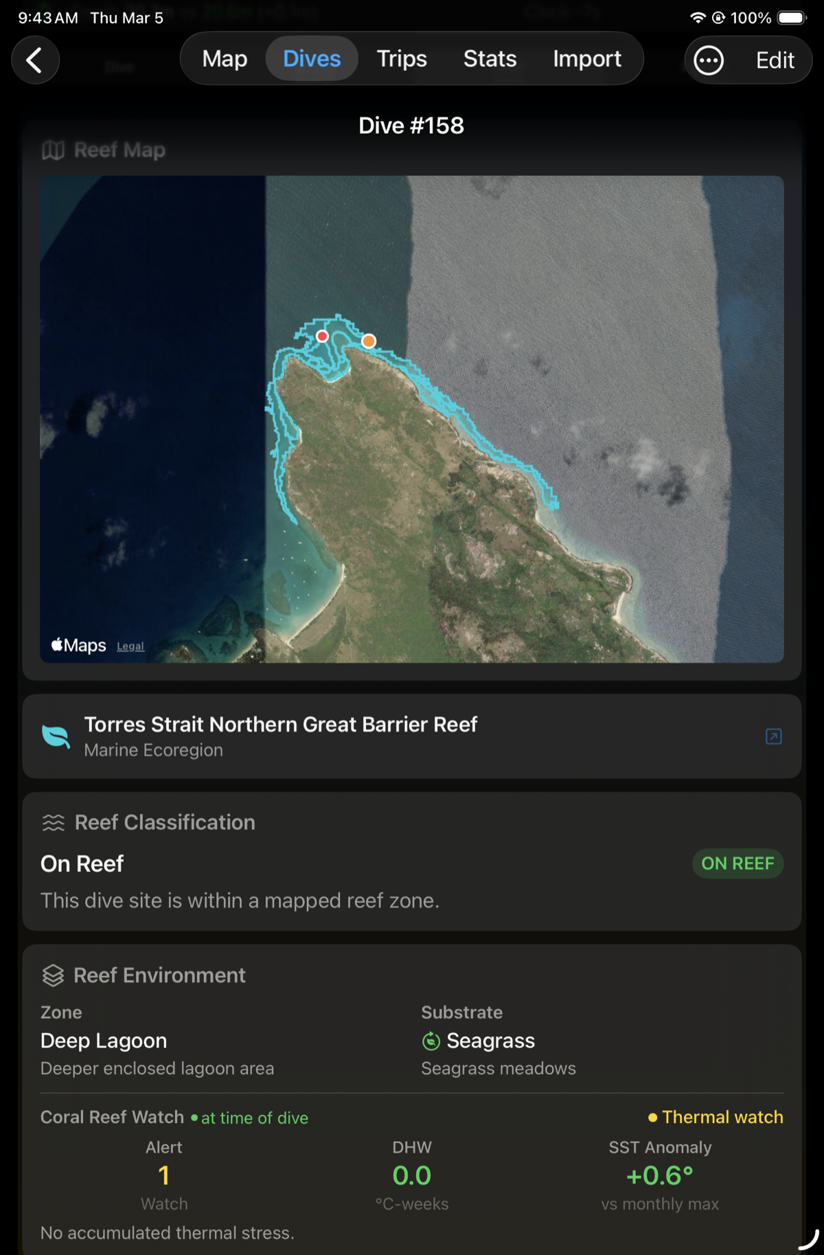
Mermaid Cove, Lizard Island. ACA geomorphic zone: Deep Lagoon. Benthic substrate: Seagrass. Entry and exit pins from Shearwater Swift GPS.
- Outer Reef Slope
- Fore Reef
- Reef Crest
- Back Reef / Lagoon
- Deep Lagoon
- Patch Reef
- Terrestrial Reef Flat
- Coral/Algae
- Seagrass
- Microalgal Mats
- Rock
- Rubble
- Sand
- Turbid
Classification follows ACA's published geomorphic and benthic taxonomy. DeepSix stores the raw class labels and displays common names.
Included, free, nothing to set up. The Allen Coral Atlas reef mapping just works on every reef dive — no account, no API key, no credentials to enter.
DeepSix is licensed to use the Atlas with the Allen Coral Atlas team's permission and queries it on your behalf. Reef polygon overlays, geomorphic zones, and benthic substrate classification are all part of the app.
Protected waters, drawn on the map.
The Reef Overlay doesn't stop where the Allen Coral Atlas does. The map also draws more than 29,000 marine protected and managed areas worldwide, at every level of protection, as dashed outlines at any zoom — including all 18 US National Marine Sanctuaries (Flower Garden Banks rendered as its 19 individual banks) and all 61 Australian Marine Parks. Open a site inside one and a Marine Protection card shows what kind of area it is and the rules that apply there.
And for Flower Garden Banks itself, a mesophotic bank below the depth range of ACA's shallow-optical satellite mapping, DeepSix fetches NOAA's deep coral-cap habitat layer live for your viewport — so the reef is on the map even where satellites can't see it.
The Atlas doesn't get the last word, either. If ACA classifies your coordinates as "not reef" but you tagged the dive as a reef, your call wins and reef context runs anyway. You were there; the satellite wasn't.
Sanctuary boundaries: NOAA (public domain). Australian Marine Parks: DCCEEW, CC BY 4.0. Worldwide managed areas: ProtectedSeas Navigator, CC BY 4.0. Attributed in Settings → Acknowledgments and the map footer.
The thermal stress your reef was under when you dived it.
NOAA's Coral Reef Watch publishes daily 5km-resolution bleaching heat stress data for every tropical and subtropical reef on the planet. DeepSix fetches three metrics for the date and location of your dive — stored permanently on your dive record, even if you import a dive from five years ago.
0–5 scale. Alert 1 = bleaching-level heat stress. Alert 2 = expect bleached corals. Levels 3–5 = severe to catastrophic.
Accumulated thermal stress over the preceding 84 days. DHW > 4 triggers bleaching. DHW > 8 causes significant coral mortality.
Sea surface temperature deviation from the monthly maximum mean. Positive values indicate above-normal heat. The early warning before DHW builds.
"No accumulated thermal stress — but the +0.6°C SST anomaly in mid-December told a different story. Early summer heat was building before the thermal budget registered. The bleached staghorn Acropora and Sinularia leathers you photographed reflect that accumulation."
Alert levels 3–5 were added by NOAA in December 2023 to cover extreme bleaching events. DeepSix stores and displays all five levels.
Every ocean boundary your dive site sits inside.
The Marine Regions Gazetteer (VLIZ) is the authoritative registry of named marine areas — ecoregions, exclusive economic zones, IHO sea areas, and hundreds of other boundary types. Every boundary has a persistent MRGID identifier, the same way a DOI identifies a scientific paper.
For every dive, DeepSix queries Marine Regions by coordinate and stores the full stack of named areas that contain your site. This feeds directly into the reef context narrative — the AI knows not just that you were on a reef, but which ocean province, which ecoregion, which EEZ.

Five layers of ocean geography, resolved from a single GPS coordinate.
- Reef (named reef feature)
- Protected Area
- Marine Ecoregion (Spalding et al. 2007)
- Exclusive Economic Zone
- IHO Sea Area
- Large Marine Ecosystem
Marine Regions returns all applicable boundaries for a coordinate. DeepSix displays the four most relevant types and stores the full result.
What's nearby. What it's called. What happened there.
GeoNames provides reverse geocoding and nearby feature lookup for every named place on earth — including marine features, wrecks, national parks, historical sites, and Wikipedia-linked locations. For each dive site, DeepSix queries GeoNames for named features within a 5km radius and retrieves Wikipedia summaries where available.
This is how DeepSix knew, for a dive at Mermaid Cove on Lizard Island, that Mrs Watson's Cottage — a heritage-listed ruin 321 meters away — was the site where Mary Watson famously fled from hostile attack in 1881 in a boiling-down pot with her infant son. The AI received that context and referenced it independently.
GeoNames returned: "Mrs Watson's Cottage — heritage-listed house ruin, Lizard Island National Park, Queensland Heritage Register (1992). 321m from dive site."
The reef context narrative referenced the same story without being told to.
Written like a scientist who dives.
The context narrative isn't generated from generic knowledge about a reef. It's built from your dive specifically — the species you identified in your photos, the bleaching you personally documented, the notes you wrote, the depth you reached, the conditions you logged. The AI receives your observations as primary data and interprets them in scientific context. The result reads like a field note written about your dive, because it is.
Five external data sources provide the scientific framework. Your photos, your species IDs, and your notes provide the substance. The prompt instructs Claude to write like a marine naturalist — specific, factual, no marketing language. If the reef is under thermal stress, say so. If a logged species has an unusual ecological connection to this site, make that connection.
Lizard Island's deep lagoon at Mermaid Cove sits over seagrass beds at nearly 21 meters, yet your species list reads like a full reef census — massive Porites, tabulate Acropora, gorgonians, and a remarkable diversity of soft corals alongside the seagrass. This site carries historical weight: Mary Watson famously fled from here in 1881 in a boiling-down pot with her infant son, a story preserved in the stone cottage ruins on the island. During this mid-December dive, the reef was under thermal watch with sea surface temperatures running 0.6°C above normal — and the extensive bleaching you documented across hard and soft corals alike, from staghorn Acropora to Sinularia leathers, reflects early summer heat accumulation even before degree heating weeks have built up. The presence of several butterflyfish species — oval-spot, saddled, reticulated, and threadfin — is worth tracking over return visits, as these obligate corallivores are sensitive indicators of coral condition and may shift in abundance if the bleached colonies you recorded don't recover.
You identified 18 fish species, 2 nudibranchs, 6 echinoderms, and 162 coral observations from your own photos using DeepSix's marine life ID. Those are your observations — not a stock species list for this reef. Claude received them and used them to characterise the ecological richness of this specific dive. A different diver on the same reef the same day would get a different narrative.
Sourced from GeoNames Wikipedia lookup for Mrs Watson's Cottage, 321m from dive site. The narrative was not told to reference this — it identified the historical significance independently.
Four Chaetodontidae species were logged. The prompt instructs Claude to connect logged species to regional ecology non-obviously. Obligate corallivores are a documented early warning metric for reef decline.
This phrase exists because bleached corals were in the diver's species list — Bleached Massive Porites, Bleached Encrusting Porites, Bleached Branching Coral — logged from photos taken during the dive. The narrative reflects what the diver actually saw and recorded, not what bleaching models predict.
- Species you identified from your photos
- Notes you wrote during or after the dive
- Bleaching and damage you documented
- Depth, duration, and conditions
- Number of previous dives at this site
- CoralWatch survey results (if completed)
- Geomorphic zone and substrate (Allen Coral Atlas)
- Bleaching alert and thermal stress (NOAA CRW)
- Marine ecoregion and EEZ (Marine Regions)
- Nearby historical and ecological features (GeoNames)
- Season and hemisphere (derived from date + GPS)
No two narratives are the same. A diver who logged nudibranchs gets a different paragraph than one who logged sharks. A dive during a bleaching event reads differently than the same site in recovery. Your notes become part of the scientific record of that reef on that day.
See the writing rules Claude follows →
- 1. Never open with "Welcome to". Lead with the most interesting sentence.
- 2. Include one fact that would genuinely surprise an experienced diver.
- 3. Connect at least one logged species to regional ecology non-obviously.
- 4. If bleaching alert ≥ 2 or thermal stress is documented: say so directly. Don't soften it.
- 5. If you've dived this site more than three times, note the temporal context.
- 6. Use italic for scientific names on first use.
- 7. 3–4 sentences. No sycophancy. No "what a dive."
Your observation. The planet's record.
Every reef dive in DeepSix includes a Report tab with a structured CoralWatch survey form — bleaching status, live coral cover estimate, and threats observed. The form follows the University of Queensland CoralWatch protocol used by researchers and citizen scientists globally.
API integration with the UQ CoralWatch database is in active discussion. In the meantime, completed surveys are stored on your dive record and exportable.

The Report tab. Bleaching status, live coral cover, and threats observed — stored on every reef dive.
CoralWatch is a citizen science program of the University of Queensland. API integration pending — data is stored locally and will sync when the integration is complete.
- ✓ Reef polygon boundary overlaid on satellite map
- ✓ Geomorphic zone and benthic substrate classification
- ✓ NOAA bleaching alert level at time of dive
- ✓ Degree heating weeks and SST anomaly
- ✓ Marine ecoregion, EEZ, and IHO sea area
- ✓ GeoNames nearby features and Wikipedia context
- ✓ Your species IDs from photos woven into the narrative
- ✓ Your dive notes included as primary context
- ✓ Bleaching you documented reflected in reef health commentary
- ✓ AI reef context narrative, regenerable on demand
- ✓ CoralWatch survey form with structured export
All of this runs automatically on every reef dive — nothing to configure, no accounts or keys.
The species you photographed.
How many are left.
Every marine animal DeepSix identifies gets a conservation check. IUCN Red List status, CITES trade tier, whether the species is native to where you saw it or invasive. Loaded from a live API when you're online, from a bundled snapshot when you're not.
A Whitetip Reef Shark identified at Flinders Reef gets a different annotation than the same species identified in the Mediterranean. The location matters. Invasive is location-dependent.
Outbreak species — Crown-of-thorns starfish, Drupella snails — are native but flagged when in bloom. Ecosystem damage doesn't require rarity.
If you see something that shouldn't be there, DeepSix generates a reporting link for the relevant citizen science program — GBRMPA Eye on the Reef, NOAA, or the appropriate authority for your location. One tap.
Live lookup from the IUCN Red List API. Bundled offline snapshot for connectivity-free dives. Status shown at the time of your dive.
Invasive status is computed from your dive GPS against the species' native ecoregion. The same fish can be native or invasive depending on where you saw it.
One tap generates a reporting link for the right citizen science program. GBRMPA Eye on the Reef, NOAA, or the regional authority for your location.
Your dive. In scientific context.
Every reef dive gets a narrative built from what you personally observed — interpreted against five layers of ocean science. Nothing to configure.
Reef classification data: Allen Coral Atlas, University of Arizona
Bleaching data: NOAA Coral Reef Watch
Marine area data: Marine Regions Gazetteer, VLIZ
- Achievements →
- AI Features →
- Apple TV →
- DeepSix Dive Log on Mac →
- Garmin FIT Import →
- Gear & Kits →
- GPS Extraction →
- Interactive Dive Map →
- MacDive Import →
- Marine Life ID →
- Photo Color Correction →
- Photos & Memories →
- Smart Lists →
- Suunto JSON Import →
- Tides & Conditions →
- Time Reconciliation →
- Translations →
- Trip Planner →
- Wonders →
- Wrecks →